
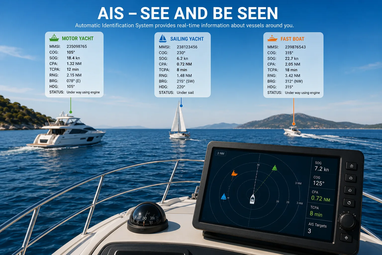
AIS Explained – Automatic Identification System for Sailors
AIS (Automatic Identification System) allows equipped vessels and shore stations to exchange identification, position, course, speed and other navigation data over marine VHF frequencies. On a chartplotter, AIS targets can help a skipper understand nearby traffic and identify potentially dangerous encounters before vessels get too close.
This guide explains how marine AIS works, the difference between AIS Class A and Class B, AIS receivers and transponders, MMSI, COG, SOG, CPA and TCPA, AIS target symbols, chartplotter integration, collision alarms, limitations and correct use alongside visual lookout, radar and COLREG.
Important Safety Note
What is AIS?
AIS stands for Automatic Identification System. It is a digital maritime communication system in which equipped vessels automatically broadcast navigation and identification information. Compatible equipment receives these reports and can display nearby vessels as targets on an AIS display, chartplotter, multifunction display or navigation software.
The practical benefit is simple: instead of seeing only an unidentified ship on the horizon, AIS may tell you its name, MMSI, position, speed and course and can help calculate how close it is expected to pass your boat.
How Does AIS Work?
A vessel's AIS equipment receives position and movement information from navigation sensors, combines it with vessel identification data and transmits digital AIS messages over dedicated marine VHF data channels. Other AIS stations within radio range receive those messages.
1. GNSS / position source
Provides position and movement data used by the AIS equipment.
2. AIS unit
Builds digital reports containing dynamic and static vessel information.
3. VHF antenna
Transmits and receives AIS radio messages. Installation quality and antenna height affect practical range.
4. Chartplotter / display
Shows received vessels as AIS targets and may calculate CPA, TCPA and collision alarms.
What Information Does AIS Show?
| Data | Meaning | Why a skipper cares |
|---|---|---|
| MMSI | Maritime Mobile Service Identity | Unique radio identity used to identify a station/vessel. |
| Vessel name | Reported ship name where available | Lets you identify and, when appropriate, call a vessel by name. |
| Position | Reported latitude/longitude | Places the target on the navigation display. |
| COG | Course Over Ground | Direction the vessel is actually moving over the earth. |
| SOG | Speed Over Ground | Actual speed over the ground. |
| Heading | Direction the bow is pointing, when available | Can differ from COG because of current, leeway or manoeuvring. |
| Navigation status | Status entered/reported by applicable AIS equipment | Useful context, but do not assume manually entered data is always current. |
| Dimensions | Reported vessel dimensions | Helps understand the size and geometry of large traffic. |
| Destination / ETA | Voyage-related data on applicable systems | Useful context, but may be manually entered and outdated. |
MMSI and AIS
The MMSI is a nine-digit maritime identity associated with radio equipment and the vessel/station. It is also used by DSC-equipped VHF radios. Correct MMSI programming is important because an incorrect identity can cause confusion during routine navigation and emergencies.
AIS Receiver vs Transponder
| Equipment | Receives targets? | Transmits your boat? | Practical meaning |
|---|---|---|---|
| AIS receiver | Yes | No | You can see AIS-equipped traffic, but they do not see you through AIS merely because you have a receiver. |
| AIS transceiver / transponder | Yes | Yes | Receives nearby targets and broadcasts your own AIS reports when correctly configured and operating. |
AIS Class A vs Class B
| Feature | Class A | Class B |
|---|---|---|
| Typical use | Commercial ships and vessels subject to carriage requirements | Common on recreational and smaller commercial vessels |
| Transmission priority / reporting | Higher-priority, more comprehensive reporting architecture | Designed for lower-demand small-vessel use; details depend on Class B technology |
| Power / range | Generally higher transmit power | Generally lower than Class A; practical range still depends strongly on antenna installation |
| Information | Broad static, dynamic and voyage-related reporting | Core identification and dynamic data; capabilities vary by implementation |
| Recreational yacht | Usually unnecessary unless specifically required | Common choice when a yacht owner wants to transmit AIS |
Class B CSTDMA vs SOTDMA
Class B equipment is not all identical. Older/lower-power implementations commonly use CSTDMA access, while Class B SOTDMA equipment uses a self-organizing time-division method and generally offers higher transmission performance. When selecting equipment, compare the exact specification rather than relying only on the words “Class B.”
AIS Range
AIS uses VHF, so practical range is strongly influenced by antenna height, antenna quality, cable losses, transmitter power, receiver sensitivity and terrain. A masthead antenna on a sailing yacht can provide substantially better line-of-sight coverage than a very low antenna.
How AIS Appears on a Chartplotter
AIS targets are normally shown as vessel symbols with movement vectors. Exact symbols and colors vary by manufacturer, so always learn the legend used by your own chartplotter.
Target symbol
Shows the reported vessel position and often its orientation or movement direction.
Vector
Projects the target's movement using COG/SOG for a configured time interval.
Selected target
Opens detailed AIS information such as MMSI, name, SOG, COG, CPA and TCPA.
Dangerous target
A chartplotter may highlight a target when CPA/TCPA crosses configured alarm limits.
CPA and TCPA Explained
CPA — Closest Point of Approach is the predicted minimum separation between your vessel and another moving target if both continue with the motion used by the calculation.
TCPA — Time to Closest Point of Approach is the predicted time until that closest approach occurs.
Why CPA Can Change Quickly
CPA and TCPA are predictions, not promises. They change when either vessel alters course or speed. At low speed, during manoeuvres, in strong current or with unstable sensor data, the displayed prediction can change significantly.
Interactive AIS Target & CPA Simulator
Use the simulator to practice interpreting an AIS encounter. Change your own course/speed and the target's bearing, distance, course and speed. The tool estimates CPA/TCPA using a simplified constant-velocity model.
▲ OWN SHIP
▲ AIS TARGET
Relative Bearing and Collision Risk
One of the oldest collision-warning principles remains useful even with AIS: if another vessel stays on approximately the same relative bearing while range decreases, collision risk may exist. AIS adds numerical information, but the skipper should still look outside and understand the geometry.
AIS and COLREG
Use AIS to support situational awareness:
- Detect and identify a target.
- Look outside and visually correlate the target.
- Check bearing, range, COG, SOG, CPA and TCPA.
- Determine whether risk of collision exists using all available means.
- Identify the COLREG situation.
- Take appropriate action if required.
- Monitor the result until the vessels are finally clear.
AIS vs Radar
| AIS | Radar |
|---|---|
| Shows cooperative targets that transmit AIS. | Can detect physical targets that reflect radar energy. |
| Can provide vessel identity and transmitted navigation data. | Usually does not inherently know a target's identity. |
| May miss vessels/objects with no AIS transmission. | Can show non-AIS boats, coastlines, rain and other detectable objects. |
| Depends on transmitted data and AIS/GNSS equipment. | Depends on radar setup, target characteristics, sea/rain clutter and operator interpretation. |
AIS and VHF Radio
AIS and marine VHF are closely related but serve different functions. AIS exchanges digital vessel data automatically, while VHF voice lets crews communicate directly. An AIS target's vessel name or MMSI can help you identify whom you intend to call, but radio calls should not be used as a substitute for clear COLREG action.
Common AIS Problems
| Problem | Possible cause | Check |
|---|---|---|
| No AIS targets | No traffic, antenna/feed issue, unit off, configuration/network problem | Power, status page, antenna, splitter, data network and known nearby traffic |
| Your boat not seen by others | Transmit disabled/fault, antenna problem, configuration issue | Transponder status, MMSI/static data and antenna system |
| Target jumps | Changing source data, reception gaps or manoeuvring | Do not rely on one instantaneous CPA/TCPA value |
| Wrong vessel name/details | Incorrect static data programming | Verify programmed vessel information |
| Constant collision alarms | CPA/TCPA limits too conservative for environment | Adjust alarm strategy without disabling useful warning |
| AIS works but chartplotter shows nothing | Data/network/configuration issue | NMEA 0183/2000/Ethernet configuration as applicable |
Can You Turn AIS Transmit Off?
Some installations provide a receive-only or silent mode, but legal requirements and appropriate use depend on vessel type and jurisdiction. Do not disable required transmissions merely to avoid being visible. Understand the rules applicable to your vessel and equipment.
Interactive AIS Departure Checklist
AIS departure check
AIS Practice Questionnaire
This interactive quiz tests practical AIS knowledge: receivers vs transponders, Class A/B, MMSI, COG/SOG, CPA/TCPA, target interpretation, radar differences and collision avoidance.
Frequently Asked Questions
What does AIS stand for?
AIS means Automatic Identification System.
Does AIS show every boat?
No. A vessel may have no AIS, may not be transmitting, may be outside reception range or may have an equipment/configuration problem.
What is the difference between an AIS receiver and transponder?
A receiver only receives AIS traffic. A transceiver/transponder also broadcasts your vessel's AIS reports when operating normally.
What is CPA?
Closest Point of Approach: the predicted minimum distance between vessels if the motion used in the calculation continues.
What is TCPA?
Time to Closest Point of Approach: the predicted time remaining until CPA.
What is COG?
Course Over Ground is the direction a vessel is moving over the earth.
What is SOG?
Speed Over Ground is the vessel's speed relative to the earth.
Can AIS replace radar?
No. AIS and radar provide different information and have different limitations.
Can AIS replace visual lookout?
No. A proper lookout remains essential.
Does a low CPA tell me who gives way?
No. CPA indicates encounter geometry; give-way and stand-on responsibilities come from the applicable COLREG situation.
Conclusion
AIS is one of the most useful modern navigation aids because it combines identification with movement information. A skipper who understands COG, SOG, CPA and TCPA can recognize developing encounters much earlier than by looking at target icons alone.
The key is to use AIS correctly: verify what you see outside, understand the target's movement, apply COLREG, and remember that vessels or hazards without AIS will never appear simply because your AIS display looks clear.
Continue reading
Build your Croatia sailing knowledge with related TwoBoat guides, software, guides and planning tools.